Veranstaltungsprogramm
Eine Übersicht aller Sessions/Sitzungen dieser Veranstaltung.
Bitte wählen Sie einen Ort oder ein Datum aus, um nur die betreffenden Sitzungen anzuzeigen. Wählen Sie eine Sitzung aus, um zur Detailanzeige zu gelangen.
|
|
|
Sitzungsübersicht |
| Sitzung | ||||
16: Hydrogeologie arider Gebiete
Sitzungsthemen: 16. Hydrogeologie arider Gebiete
| ||||
|
| ||||
9:45 - 10:00
ID: 278 / Thema 16: 1 Vortrag Themen: 16. Hydrogeologie arider Gebiete Stichworte: 19. Brunnen und Quellfassungen – Anforderungen, Untersuchungsmethoden, Erfahrungen Grundwasserübernutzung in Jordanien Bundesanstalt für Geowissenschaften und Rohstoffe, Jordanien Eindrücke aus der technischen Entwicklungzusammenarbeit im Bereich Grundwasser- und Brunnenmanagement Die arabische Halbinsel gehört zu den trockensten Regionen der Erde. Jordanien ist eines der wasserärmsten Länder der Welt. Ein Großteil der Grundwasservorkommen ist fossil. Die Bevölkerungszunahme, das Wachstum in der Landwirtschaft, klimatische Veränderungen – dies alles trägt zur Verschärfung der Wassersituation bei. Diese Tatsachen sind wohl bekannt und häufig zu lesen. Aber was bedeutet es wirklich, wenn die Grundwasserreserven dermaßen rapide abnehmen? 10:00 - 10:15
ID: 333 / Thema 16: 2 Vortrag Themen: 16. Hydrogeologie arider Gebiete Hydrochemistry of groundwater in Jordan – a nation-wide assessment 1Bundesanstalt für Geowissenschaften und Rohstoffe, Deutschland; 2Water Authority of Jordan, Jordanien The groundwater in Jordan is under heavy stress. Pumping from wells not only lowers the table of the groundwater, but also changes its chemical composition substantially. Saltwater upconing can happen at any well, which is improperly operated and the entry of oxygen into a deep aquifer can change the redox milieu in a way, that geogenic contaminants are mobilized. While decisionmakers and the general public tend to focus on the more obvious quantitative aspects, the “Water Authority of Jordan” (WAJ) is responsible for the monitoring of water quality at all abstraction points. Between 2020 and 2022, WAJ performed a nation-wide assessment of groundwater quality in cooperation with BGR. A total number of 440 production wells (governmental and private, as well as springs) was sampled, addressing all relevant aquifer units in the country. In the aftermath, 88 sampling points were selected to be sampled in the scope of an annual water quality monitoring (AWQM), assessing the dynamics of the hydrochemical development in the groundwater over the next years. They were selected with regard to their geographic location and the addressed aquifer. The AWQM is considered crucial by WAJ to document trends of increasing TDS and the mobilization of unwanted contaminants of anthropogenic or geogenic origin (e.g. Se, Mo). The results are published on a Water Quality Dashboard, which is based on the open-source toolbox “Grafana”, to be available online and give the public and decisionmakers a better understanding of the water quality situation in the Jordanian underground. The dashboard is complemented with background information about the hydrogeology of Jordan and the most important hydrochemical parameters. Thus, the dashboard is not only meant to serve experts as a tool for a better overview, but also targets the interested public to raise awareness for the groundwater quality situation in the country. The results of this work can be used as a planning and management tool in all parts of the Jordanian water sector. Furthermore, it serves as a starting point for anybody, who wants to conduct groundwater quality-related research in the country. 10:15 - 10:30
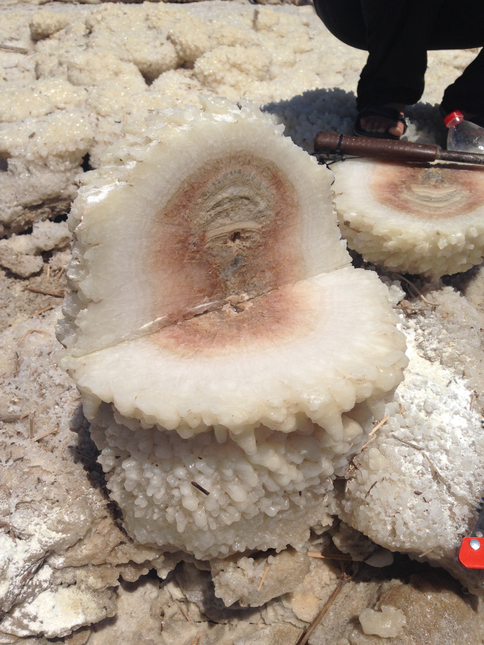
ID: 145 / Thema 16: 3 Vortrag Themen: 16. Hydrogeologie arider Gebiete Stichworte: 11. Grundwasser: Interaktionen mit der vadosen Zone und Oberflächengewässern Cold smokers - a rare phenomenon of SGD 1Helmholtz-Zentrum für Umweltforschung UFZ, Dept. Catchment Hydrology, Deutschland; 2Leibnitz-Institute of Freshwater Ecology and Inland Fisheries, Experimental Limnology, Stechlin, Germany; 3Helmholtz-Zentrum für Umweltforschung UFZ, Dept. Monitoring und Erkundung, Deutschland; 4University of Vienna, Isotope Physics, Vienna, Austria; 5TU Bergakademie Freiberg, Scientific Diving Centre, Freiberg, Germany; 6GFZ Helmholtz Centre Potsdam, German Research Centre for Geosciences, Section 3.4, Potsdam, Germany; 7ANU – Australian National University, Research School of Physics, Dept. Nuclear Physics & Accelerator Applications, Canberra, Australia; 8TLUBN – Thuringian State Office of Environment, Mining and nature protection, Ref. 8.1, Weimar, Germany; 9Geological Survey of Israel, Jerusalem, Israel The modern Dead Sea (DS) is a hypersaline terminal lake, which fills a deep tectonic depression within the Jordan-Dead Sea Rift System. Missing inputs, high evaporation and pumping let the lake surface drop with an average rate of 1 m/a, leading to a shore line at -437 m mean sea level in 2022. The lake’s Mg-dominated brine shows increased salinity (TDS = 350 g l-1) and density (rho = 1.237 g cm-3), respectively and is characterized by halite oversaturation and halite deposition on the lake bottom. The basin is filled with roughly 7 km of Neogene-Quaternary marine, lacustrine, evaporite and fluviatile/deltaic sediments. The upper 50-70 m are the Pleisto-Holocene deposit of the DS, the successor of Lake Lisan that disappeared 10-15 ka ago. The lacustrine DS sediments consist of lamina of aragonite, gypsum and clay minerals, embedded autochthonic halite (layers) and at least one thick bed of rock salt at the base, marking the end of the Lisan period. Contrastingly, side wadis transported fluviatile sediments producing fans of coarser clastic detritus from the catchment, which become finer towards distal parts and intercalate the lake laminae. Surface- and groundwaters from the surrounding mountainous areas follow the steep gradients towards the lake. Groundwater, recharged in the highlands flow through the Cretaceous aquifers towards the DS and into the fluviolimnic DS deposits. While fans represent conductive zones, the DS sediments show negligible matrix flow but permeable secondary porosity. While passing, groundwater leach soluble components, particularly the thick salt layer, which refers to the birth period of the Dead Sea 10,000 years ago. As a result, thousands of sinkholes occurred during the last 4 decades - collapse structures that particularly affect the west coast of the lake. Eventually groundwaters emerge with variable salinities through on- and offshore springs as documented by scuba divers down to depths of at least 35 m. During SCUBA dives repeatedly detected along the western shore, submarine discharging groundwater leads to the generation of salt chimneys, a phenomenon so far unknown from any other place in the world. Subaquatic chimneys composed of sulphides and carbonates are known from Mid Ocean Ridges and abyssal submarine volcanoes. Chimneys built of very soluble salts have not been described yet. Only in the hypersaline DS, that new form of cold-water smokers was found, rising up from the bottom of the DS. They result from the difference in chemical composition between the invading saturated halite dissolution brine and the Dead Sea, which is at halite saturation too but holds a remarkable chloride excess. At the chemical interface with the DS brine, halite precipitates instantaneously, forming chimney pillars of several meters in height and up to meters in diameter. Chemical and isotopic evidences indicate, the brine leading to the formation of these chimneys is the result of fresh groundwater, leaching a massive halite layer in the subsurface adjacencies of the lake. That process however is associated with the falling level of the Dead Sea and the increasing development of onshore sinkholes. Thus, salt chimneys indicate intense subsurface cavitation and are easily to detect by e.g., drone-based aerial imaging or echo-sounding bathymetric surveys and provide a potent, predictive tool to locate shore areas that may collapse in the near future.
10:30 - 10:45
ID: 184 / Thema 16: 4 Vortrag Themen: 16. Hydrogeologie arider Gebiete Stichworte: 10. Methoden zur Bestimmung der Grundwasserneubildung Berücksichtigung von Trockendeposition in Chlorid-Massenbilanzen zur Neubildungsabschätzung: Ja, nein, vielleicht Institut für Angewandte Geowissenschaften, Technische Universität Darmstadt, Deutschland Chlorid-Massenbilanzen (CMB) sind eine beliebte Methode, um Grundwasserneubildungsraten abzuschätzen, vor allem in ariden Gebieten. Da das Verfahren mit relativ wenigen Parametern auskommt (atmosphärischer Chlorid-Eintrag, mittlerer Niederschlag, Chlorid-Konzentration im Untergrund), wird es für seine (scheinbare) Einfachheit geschätzt. Einige erforderliche Daten sind tatsächlich leicht zu erheben, jedoch ist der atmosphärische Eintrag über nasse und trockene Deposition schwieriger zu bestimmen als es auf den ersten Blick erscheinen mag. Um einen Einblick zu bekommen wie die Methode von Forschenden angewendet wird, wurde eine Literaturstudie durchgeführt. Der Fokus lag hierbei auf der Frage wie in den CMB-Studien der atmosphärische Eintrag gemessen wurde. Die Analyse zeigte in dieser Hinsicht eine erstaunliche Heterogenität. Während einige Artikel die Wichtigkeit der Trockendeposition hervorheben, wird diese in anderen gänzlich ignoriert. Überraschend oft machen die Autoren keinerlei Angaben wie der atmosphärische Eintrag bestimmt wurde oder wie viele Proben dafür zur Verfügung standen. Dieser Beitrag präsentiert keine “Musterlösung”, sondern stellt einen Aufruf zu mehr Transparenz in CMB-Untersuchungen dar. | ||||
Impressum · Kontaktadresse:  Datenschutzerklärung · Veranstaltung: FH-DGGV 2024 |
Conference Software: ConfTool Pro 2.8.101+TC © 2001–2024 by Dr. H. Weinreich, Hamburg, Germany |
